Top 10 Reasons Not To Build A Road On The Parkway Greenspace

ParkwayMapPIC3.jpg

The Friends of Jackson Park and the Friends of Peterborough Trails have compiled a list of the Top 10 Reasons Not to Build a Road on the Parkway Greenspace. Here they are...

1. The Parkway is not a solution to our traffic problems

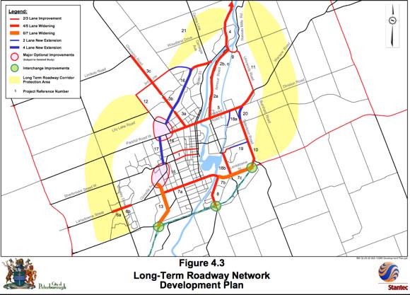
The proposed Parkway fixes perhaps one-tenth of our traffic problems in the north end of the City. It links one fifth of the City’s planned north end residential areas to only one of the two main employment areas in the City. The City proposed the original "Parkway" route to bypass the city limits as they were in 1947. Other options better connect the places where we live to the places we work.

2. The Parkway Greenspace is one of Peterborough’s most precious assets

The Parkway Greenspace corridor is the largest and most significant natural habitat and open space in the north end of Peterborough, and one of the largest areas of green space in the City. It is a key part of the City trails network. The Parkway route also serves as an important wildlife corridor, along which wildlife can traverse a large swath of the city. It allows citizens, and most importantly our children, to observe wildlife and connect with nature.

3. The Parkway is not the best investment of our hard earned tax dollars

The projected cost of the Parkway is around 40 million dollars. This does not include costs to deal with noise, flooding and other infrastructure. Realistically, the price could be easily around $50-­‐60 million. Do you want your taxes increased to pay for a road that doesn’t meet Peterborough’s needs; a road a majority of us don’t want, all for a time saving of one to three minutes? We have other critical spending priorities, including fixing the many poorly maintained roads we already have.

4. When given the opportunity to actually choose, the people of Peterborough said “No Parkway”

The Parkway has been a contentious issue in Peterborough for many decades. It was turned down by 55% of voters in a referendum in November 2003. Following that vote, City Council ordered the Chief Administrative Officer to have the Parkway removed from the Official Plan. This did not occur. Why was the voice of the people not respected and the why was the direction of Council not acted upon?

5. The Parkway Greenspace promotes a healthier population

Greenspace encourages people to get outside, to walk instead of drive, to interact with each other and connect with the natural world around them. Greenspaces are proven to support a better sense of community and improved mental health. The greenspace provides a place for city children to explore and play, for free, no matter what their financial means. We have an obesity epidemic costing us billions of dollars and untold health problems. Do we need to make the situation worse?

6. The Parkway Greenspace supports our children and our schools

There are five schools along the Parkway corridor. The Parkway will run directly alongside two primary schools. Putting a major arterial road directly next to or near these schools increases risks to students. Also, a main arterial road will eliminate safe opportunities for students to learn about science and nature, conduct their own research and experience outdoor education in a natural setting.

7. Previous consultants said we don’t have a problem, now or in the future

In their report to City Council on April 18th, 2011, consultants Morrison-­‐Hershfield reported that even with no road improvements beyond those presently committed, the best performance models for 2031 show no significant congestion except around river crossings. This congestion is not addressed in any of the proposals related to the Parkway.

8. We are not growing as fast as projected so do we really need a new road?

Growth projections prior to the 2012 Comprehensive Transportation Plan turned out to be optimistic, and current slow economic progress and an ageing demographic may impact the projections used in the 2012 Plan.

9. The Parkway Greenspace supports Provincial planning directives

A 2012 Ministry of Municipal Affairs and Housing Provincial Policy Statement on Land Use Planning requires all municipalities to have and protect natural heritage systems that include natural corridors and linkages such as Jackson Park and the Parkway Greenspace corridor. A decision to build a road through these natural corridors would be contrary to such provincial directions

10. Paving the Parkway Greenspace will certainly lead to a bridge through Jackson Park

You only have to look at the incremental history of the “Parkway by Stealth” campaign to see that this will happen (despite the promises it won’t). When the southern and northern parts of the Parkway are finished, do you think they will leave a big bend around Jackson Park between the two?

If you believe in permanently protecting the Parkway Greenspace and Jackson Park, please let your councillor know. Alternative 2 (Fairbairn/3rd Line) is a far more effective route than the Parkway for connecting the places people live and where they work and shop, now and in the future. The Fairbairn/3rd Line route will not see the destruction of our precious greenspaces and makes even more sense given the many fewer residences affected and the proposed Lily Lake housing development.

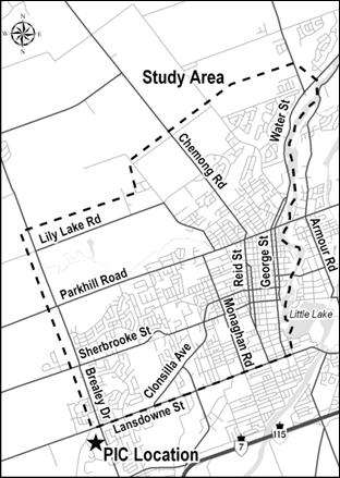
Join us at the next Parkway EA meeting Thursday, June 27th from 4:00 pm -­‐ 9:00 pm at the Peterborough Wellness Centre. This is the last time you will be able to ask questions about the route before the final proposal is presented to City Council in September!

---------------------------

[Contributed by PtboCanada's Evan Holt]

Tip us at tips@ptbocanada.com. Follow us on Twitter @Ptbo_Canada or Like us on Facebook.

Parkway Public Information Centre Meeting No. 3

ParkwayMapPIC3.jpg

The third Parkway Public Information Centre Meeting is taking place on Thursday, June 27th at the Peterborough Sport and Wellness Centre from 4 p.m. to 9:00 p.m. Come see the latest proposals to route traffic through our city.

Two presentations will be held, followed by discussion. The same information will be offered at each presentation. Study Team representatives will be at the PIC to present a series of displays for you to review the Study background, the evaluation of the Network Alternatives, the Recommended Network Alternatives and associated design concepts. This PIC will give the public an opportunity to ask questions and provide comments to the Study Team.

The first presentation is at 4:30 p.m., and the second is at 7:00 p.m.

[Related:Some Findings And Input From The Parkway Road Meeting On Impact On Community]

[Contributed by PtboCanada's Evan Holt]

Tip us at tips@ptbocanada.com. Follow us on Twitter @Ptbo_Canada or Like us on Facebook.


Read This Email On Parkway Corridor Environmental Assessment Study

Here's an email reply that Peterborough resident Susan Nelson has shared when she asked that perhaps installing advance green lights along Monaghan might be a good starting point for helping with north/south traffic flow efficiency.


Dear Ms. Nelson,

Thank you for taking the time to submit your comments on the Parkway Corridor Environmental Assessment Study.

We acknowledge your comments and agree that Monaghan Rd is not well suited and does not provide sufficient capacity to accommodate the long term growth in traffic in the City of Peterborough. Given the lack of separate left turn lanes at most of the intersections along Monaghan Road, it is virtually impossible to provide efficient traffic signal control with advance greens to provide protected left turns at intersections. This type of signal operation works best when there are separate left turn lanes at intersections and detectors can be imbedded in the pavement in the left turn lane, to indicate when vehicles are waiting for an advance green phase. The traffic signal controller can then provide an advance green move in one direction or both directions if there is demand to warrant the advance green phase. 

Without a separate left turn lane, there is no way to know if a vehicle stopped at the intersection is intending to proceed through the intersection or is planning to turn left. Without separate turn lanes, the only way to provide the advance green is to provide it for every cycle of the traffic signal irrespective of any vehicles actually wanting to turn left. To provide advance greens in both directions at the same time, would require a separate signal phase to only allow left turning vehicles to proceed first, followed by the through vehicles later. Again this would occur regardless of the presence of a left turn vehicle at the stop line, and even if the left turning vehicle was second or third in the line, they would be blocked and not be able to use the advance green.

Unfortunately, Monaghan Road is quite narrow, as I am sure you are aware, and the widening of this road to provide separate left turn lanes, even at the major intersections, would result in significant impacts to adjacent properties; would eliminate the sidewalks and boulevards; and would remove many of the mature trees along this corridor. Even if the City did undertake this improvement to Monaghan Road, this would not address the remaining problem areas that have been identified early on in our study. The recent construction of Medical Drive, provided some relief in the volume of through traffic using Monaghan Road, and the potential extension of Medical Drive to better connect to the major road network in the south end of the City would further reduce the traffic demand on the Monaghan Road corridor, and would also relieve congestion on Clonsilla Ave.

Forecasts of future planned growth in the north end of the City combined with growth in employment in the south-west end of the city will lead to increased travel demands on the arterial road network in the north end of the City as well. This will be particularly noticeable on the Parkhill Road corridor, with the increase in traffic trying to get to Chemong Road and Fairbairn Street, for example. This growth will increase the current left turn demands at the Parkhill Road intersections with Medical Drive, Monaghan Road, and Fairbairn Street and further increase congestion levels beyond those experienced today. Increased congestion and delays have been linked to increased collision risk as well, as frustrated drivers take chances in finding a gap in traffic. 

For that reason, this study is examining a number of alternatives to address longer term growth in travel demand in the City, that builds upon the recommendations of the recently completed Transportation Master Plan(2012). For the Parkhill Road area, two basic alternatives are being studied to provide capacity to accommodate future north south travel demands. One alternative includes an extension of Medical Drive north with a new bridge across the Jackson Creek Valley (as noted in your email) to connect to Fairbairn Street and a new two lane roadway in the Parkway Corridor north to Cumberland Avenue. The second alternative includes the widening of Parkhill Road to provide separate left turn lanes at Monaghan Road and Fairbairn Street (or a traffic circle), plus a widening of Fairbairn Street to 4 lanes to connect to the Parkway Corridor in the vicinity of Highland Road. 

There are advantages and disadvantages with each alternative. For example, a new bridge across the valley would be expensive, would impact vegetation and habitats in the valley, and may reduce the enjoyment of the trails and park areas to the south of the crossing location, just to name a few. The widening of Fairbairn Street would either require the removal of up to 25 homes along the east side of Fairbairn Street, or widening on the west side of the road; with extensive fill, retaining walls, and loss of trees and vegetation within the valley. Conceptual designs for each of these alternatives were provided at the Public Information Centre held on March 21, 2013. These alternatives were presented to the public for comment prior to the project team completing our evaluation. No decisions have been made on these alternatives as this point in time. Based on input received and a technical assessment of the alternatives, the project team will present a recommendation to the community at our next public meeting, tentatively planned for June 2013. 

If you haven’t had the opportunity, I would encourage you to review the material from the first two Public Information Centers for this project on the City of Peterborough website at the following link

If you have any trouble downloading the material please let me know and we will arrange to have a copy sent to you. Please note some of the files are quite large.

The City as recently agreed to extend the comment period for PIC 2 until April 19, 2013 to allow additional time for members of the public to familiarize themselves with the study, the information that has been presented so far, and the full range of alternatives under consideration. 

Comments received after the April 19th deadline will also be reviewed and included as part of the study process and documentation.

We have added you to our study email list and will notify you in advance of the next public meeting.

We look forward to receipt of any additional comments you may have on the study.

Regards,

Kevin Jones
Project Manager
D 905-668-4021 ext 2515


Stay up-to-date by following the Friends of Jackson Park Facebook Group and Friends of Peterborough Trails website. Remember that all feedback for the Parkway Extension and protection of Jackson Park must be in by this Friday (April 19th) at AECOM. Email your thoughts to kevin.jones@aecom.com and be sure to include your full name and address to validate your input.

[Contributed by PtboCanada's Evan Holt]

Tip us at tips@ptbocanada.com. Follow us on Twitter @Ptbo_Canada (hashtag #bethechangeptbo) or Like us on Facebook.


Parkway Public Information Centre Meeting No. 2 Is This Thursday

The second Parkway Public Information Centre Meeting is taking place this Thursday (March 21st) at the Evinrude Centre from 5:30 to 8:30 p.m. Come see the latest proposals to route traffic through our city.

"At PIC #1, held in October 2012, the Study Team presented the
problems and opportunities in the road network, the assessment of
the Alternative Solutions to address the identified problems/opportunities, preliminary Network Alternatives and the proposed evaluation criteria to assess the Network Alternatives. Since PIC #1, comments received from the public have been reviewed and considered by the Study Team and the Network Alternatives and associated evaluation criteria have been confirmed. The purpose of PIC #2 is to present the evaluation of the Network Alternatives and the Recommended Network Alternative."

Download the .PDF from the City of Peterborough to learn more. There will be a presentation at 7 p.m., with discussion afterwards.

[Related: Some Findings And Input From The Parkway Road Meeting On Impact On Community]

[Contributed by PtboCanada's Evan Holt]

Tip us at tips@ptbocanada.com. Follow us on Twitter @Ptbo_Canada (hashtag #bethechangeptbo) or Like us on Facebook.


Woman Drives Vehicle Through The Door Of A Tim Hortons In The Patch (And Then Orders Coffee)

So we ordered a coffee in the Tim Hortons this morning on Lansdowne (the one in front of Sobeys near the Parkway), and asked one of the servers, What's up with the door being boarded up? (see pic at left).

She explained that yesterday morning during her shift, an older woman basically drove her car right into the store, then got out of the vehicle, came in the store (well, she was already in), ordered coffee, and sat down. The server said she (and the staff) had never seen anything quite like that before.

Obviously police were on scene shortly thereafter.

Tip us at tips@ptbocanada.com. Follow us on Twitter @Ptbo_Canada.

Hey, Where Did That Building Go?

What was once a Quiznos (as well as a candidacy office and a coffee shop) at the corner of Lansdowne and the Parkway is now no more.

No word on what's going there now.


Tip us at tips@ptbocanada.com. Follow us on Twitter @Ptbo_Canada.